
 1 year ago
 (200 x 200 px).png)
In its Tuesday forecast, the National Weather Service said that “widespread moderate to major river flooding is ongoing” or expected across southeast South Dakota, southern Minnesota and northern Iowa into next week. Thursday and Friday were the wettest span in South Dakota’s recorded history, according to NWS records dating back to 1893. River flooding took out a railroad bridge in the state and caused the partial collapse of the Rapidan Dam in southern Minnesota.
Meanwhile, the brutal heat wave continues in the United States. Some 64 million people were under heat alerts Tuesday, with the National Weather Service predicting heat index values as high as 110 in some parts of the southeast. (Heat index is a measure that combines air temperature with relative humidity.) Last week, a blast of heat in New England set daily records in Hartford, Connecticut, and Bangor and Portland, Maine, among other places. The heat-strained infrastructure in the Northeast caused travel delays for tens of thousands of commuters.
 Commuters wait for a train in New York on June 20. Adam Gray / Bloomberg via Getty Images
Scientists with ClimaMeter, a consortium that analyzes extreme events, found that temperatures in the eastern U.S. were at about 3.5 degrees Fahrenheit hotter than similar heat waves in the past, largely because of human-caused climate change.
Meanwhile, temperatures in Las Vegas are trending more than 11 degrees above normal for the month of June, which is on pace to be the region’s hottest-ever. The average temperature in Las Vegas has been 93 degrees.
The current heat wave followed one that primarily affected Mexico and Texas earlier this month. More than 1,200 daytime high temperature records in the U.S. were broken from June 1 to 15. That heat wave was 35 times more likely because of climate change, according to a flash study from the World Weather Attribution Group.
Texas also endured heavy rain and flooding along the Gulf Coast on Thursday as the first named storm of the season, Tropical Storm Alberto, approached and then made landfall in Mexico. Forecasters say conditions are ripe for a banner Atlantic hurricane season. That’s because ocean waters are record hot, as they’ve been for more than a year. Daily sea surface temperatures have set new records for more than 15 months, according to the University of Maine’s Climate Reanalyzer. That ocean heat, in combination with expected La Niña conditions, led the National Oceanographic and Atmospheric Administration to predict eight to 13 hurricanes and 17 to 25 named storms by late November, when the season ends.
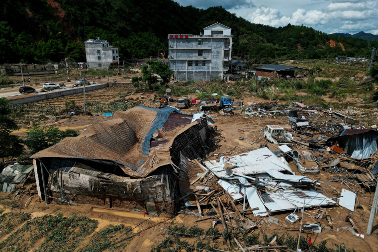 The aftermath of flooding in Meizhou, in southern China's Guangdong province, on June 21. AFP - Getty Images
Elsewhere in the world, downpours in southern China killed at least 47 people last week. Extreme rainfall touched off landslides, floods and mudslides in China’s Guangdong province. One town received more than 14 inches of rainfall.
New Delhi has been roasting in extreme heat. In a monthslong heat wave that peaked in late May, India’s capital reported temperatures exceeding 120 F, according to the India Meteorological Department. The city has seen frequent power outages and is dealing with a severe shortage of drinking water.
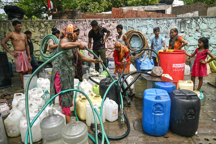 Residents fill their containers with water supplied by a municipal tanker in New Delhi on June 21. Arun Snakar / AFP - Getty Images
In Saudi Arabia, more than 1,300 deaths were reported during the Hajj pilgrimage, which was performed by more than 1.8 million Muslims this year. Daily high temperatures at holy sites in Mecca reached 120 F as worshippers arrived. Some pilgrims were seen fainting and collapsing.
The heat waves have kept climate scientists busy as they seek to understand what’s driving these events.


 English (US) ·